Introduction
MapTools allow you to find the coordinates of locations, measure distance or area, or find locations using bearing and distance by drawing shapes on the map.
Menu Bar
- Clear Map
Removes any markers, lines, polygons, etc from the map
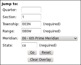
- Jump To Section
Displays the Jump To Section dialog box, which is used to navigate directly to a given coordinate in the Public Land Survey System (PLSS).
-
Quarter
The quarter section. For example, "NW" for the north west quarter of the section. Quarter-quarters are also accepted. For example, "SENW" refers to the South East quarter of the North West quarter of the given section.
-
Section
The section number, usually from 1 to 36.
-
Township
The Township, a number followed by N or S. For example, 003N, 3N, 016S, 16S.
-
Range
The Range, a number followed by E or W. For example, 080W, 80W, 012E, 12E.
-
Meridian
The meridian to be measured from.
-
State
The two letter abbreviation of your state. For example, CO for Colorado or TX for Texas.
-
Go
Highlights the section on the map, scrolls the map to it, and switches the map to the PLSS map type.
-
Reset
Resets the form to default values
-
Clear Overlay
Removes the previously displayed overlay from the map.
-
Quarter
- Search
Type a place name in the Search box and press Enter to search.
- Clear Search Markers
Clear all seach markers currently displayed
Controls
-
 Marker
Click on the map to place a marker. Clicking on a marker will display its latitude, longitude and UTM on the map. Move it with the Hand button. Double-clicking a marker will delete it.
-
 Measure Distance
Click on the map to add points. Double-click to end the line and display the line's length underneath the map. Edit points with the Hand button.
-
 Measure Area
Click on the map to set points in a polygon. Click on the first point or double-click to close the polygon. Edit points with the Hand button.
-
 Bearing and Distance
Click on the map to place a marker at the initial point. Click the Hand button and then move the marker to find bearing and distance. Once you begin moving the marker, the distance and heading from its original location will be displayed above the map. Click the Bearing and Distance button again to chain bearing and distance measurements together. Use the ending location of the previous measurement as the initial point for the successive measurement.
-
 Edit Points
Click and drag points on a line or polygon to change the shape. Clicking on a line or polygon will display the length or area under the map. Double-clicking a shape will delete it. If you have drawn multiple lines/polygons, you can find the measurements of them by adding or adjusting a point on the line or shape.
-
 Pan
Pan
Click on the arrows to pan the map. You can also click and drag on the map to move it.
-
 Zoom
Zoom
Click on the + or - icons to zoom in and out. You can also use your mouse's scroll wheel to zoom.
 Map
Map
Use the Map buttons to display different map types or satellite imagery
Polygons
Note: Creating a self-interesecting polygon may create erratic results. For example:
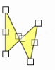 Self-interesecting Polygon |
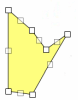 Simple Polygon |
Accuracy
Note: over very long distances (continents), there will be a small inaccuracy because Google Maps calculates distances as if the earth was a sphere. It's generally no more than 0.5%. References:
- http://code.google.com/apis/maps/documentation/javascript/geometry.html
- http://www.movable-type.co.uk/scripts/latlong.html#ellipsoid
About
MapTools provided by High Country Hydrology. Map data provided by Google Maps, the U. S. Bureau of Land Management (BLM), the U. S. Geological Survey (USGS), Boulder County and DRCOG Regional Data Catalog